INFO@CATARAQUICEMETERY.CA
(613) 546-6545
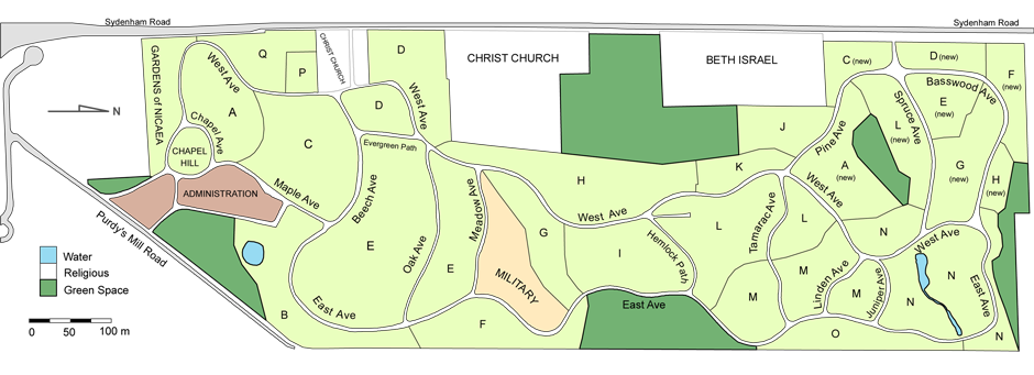
Map of Cataraqui Cemetery
Spanning approximately 85 acres, Cataraqui Cemetery is a historic cemetery landscape in Kingston. To help you navigate the cemetery, the map below illustrates the main roadways and paths throughout the grounds.
As you travel through the cemetery, we encourage you to take in the numerous vistas, gardens, artistic monuments, and landscape features that define this unique setting. Cataraqui Cemetery is both a place of remembrance and a living heritage landscape that continues to serve families today.
Should you require assistance locating a specific grave, niche, crypt, or section, you are welcome to contact our office during business hours:
Monday to Friday, 8:30 a.m. to 5:00 p.m. (excluding holidays).
The dark green areas shown on this map represent open lands within the cemetery that are reserved for future interment sites, green space, or cemetery operational needs.
The areas noted as Christ Church and Beth Israel are independent cemeteries serving those congregations and are not part of Cataraqui Cemetery. Please contact those organizations directly should you have concerns or questions related to those cemeteries.
As Kingston’s not-for-profit provider of cemetery, cremation, funeral, and monument services, Cataraqui Cemetery and Funeral Services offers families the convenience of many services under one property. Families find peace of mind knowing their cemetery, cremation, funeral, and monument needs can be managed by one accommodating and experienced provider.
Click on the map below to download a printable version.